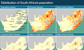
The population of each of South Africa’s nine provinces varies enormously. According to Statistics South Africa’s 2024 population estimates, the most populous provinces are Gauteng and KwaZulu-Natal, and the emptiest the Northern Cape and Free State.
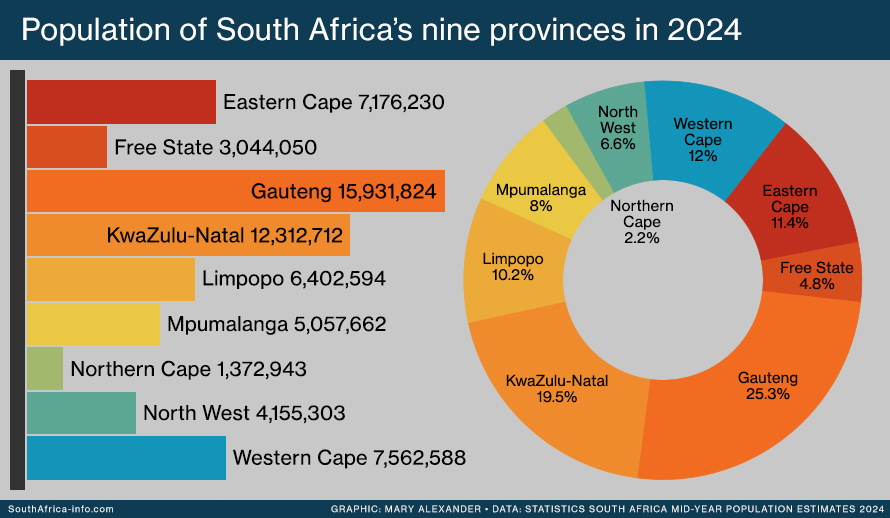
The most striking difference is between Gauteng and the Northern Cape. Gauteng is a city region of just 18,178 square kilometres, 1.4% of South Africa’s land area, yet it’s home to over a quarter of the country’s people. The Northern Cape takes up almost a third of South Africa, but it is a region of arid wilderness and hardscrabble farmland in which only 2.2% of the population live.
Then there’s KwaZulu-Natal, home to almost a fifth of the population, and the Free State, home to only 5%.
In 2024 South Africa’s provincial populations, and their share of the total, were:
- Eastern Cape: 7,176,230 (11.4%)
- Free State: 3,044,050 (4.8%)
- Gauteng: 15,931,824 (25.3%)
- KwaZulu-Natal: 12,312,712 (19.5%)
- Limpopo: 6,402,594 (10.2%)
- Mpumalanga: 5,057,662 (8.%)
- Northern Cape: 1,372,943 (2.2%)
- North West: 4,155,303 (6.6%)
- Western Cape: 7,562,588 (12.%)
- Read more: South Africa’s population
Written and designed by Mary Alexander.
Updated 10 March 2024.
More infographics
 |
 |
 |
 |
 |
 |
Categories: Infographics, People
You must be logged in to post a comment.