
Commons:Graphic Lab/Map workshop
| Illustration Workshop | Map Workshop | Photography Workshop | Video and Sound Workshop |
 Map workshop
This workshop is part of the Graphic Lab, a project aimed at picture retouching to improve the graphical content of the Wikimedia projects. More information about the lab can be found on its main page and requests pages (Illustrations ; Photographs ; Maps ; Video and Sound). To ask questions or make a suggestions, see the talk page of the graphic lab page.
This specific page is the requests page for the Map Workshop. Anyone can make a request for a map to be created or improved. The standard format for making a request is shown below, along with general advice, and should be followed.
Make a request
Use the following template when making a new request, replacing the examples with your image(s) and request(s):
<gallery>
 IMAGENAME.EXT|Description of image
 IMAGE#TWO.EXT|2nd image (If there is one)
 ETCETCETC.EXT|Don't request too many at once, though
</gallery>

;Request:
: Details of your request go here… --~~~~
;Graphist opinion(s):
See also
[edit] |
SpBot archives all sections tagged with {{Section resolved|1=~~~~}} after 7 days and sections whose most recent comment is older than 185 days. For the archive overview, see /Archive. The latest archive is located at /Archive/2025. |
Maps of the Principality of Monaco
[edit]- Request
- All maps of the Principality of Monaco should now feature the new Mareterra district, built on the sea and opened to the public in December 2024. --InfattiVedeteCheViDice (talk) 08:52, 23 January 2025 (UTC)
- Graphist opinion(s)
- The district was opened as Le Portier. Mareterra was the name at time of construction. --Minoa (talk) 01:51, 4 August 2025 (UTC)
Update and vectorize biomes of Turkey
[edit]-
 source
 -
 crop
crop -
 version by LápizRoto


I used an online tool to crop but I could not figure out how to save it as svg
Article(s): en:List of ecoregions in Turkey and others
- Request
- I looked in “Category:Biome maps” but I could not find anything. I would like to add the names of the biomes so they can be translated.
Could you possibly update per [1][2]? --Chidgk1 (talk) 11:12, 10 March 2025 (UTC)
- Graphist opinion(s)
- Chidgk1, please take a look. I got the names of the biomes directly from the source SVG (I also tried your links, but they were confusing and didn't seem to align exactly with the source details). If you would like me to make any other changes, just let me know exactly what you need. Or if you're happy with the result, let me know too. LápizRoto (talk) 06:35, 28 June 2025 (UTC)
- @LápizRoto Sorry for extremely late reply - for some reason I only just noticed you had done this. Thank you very much. I especially like the well-placed legend box.
- I see that @Terpsichores created Western palearctic biomes.svg in 2012 based on WWF data. I understand that WWF later passed the responsibility for maintaining such data to One Earth hence my links. So I think the reason for the non-alignment you mention is that the biomes have been updated since 2012. For our map to be up to date, if possible I would like the One Earth maps to be used and cited as our source not WWF.
- Also the One Earth maps look better as they have fewer lines. Would it be possible for you to update per One Earth? If you need me to contact them via https://www.oneearth.org/contactus/ please let me know. Chidgk1 (talk) 07:07, 11 September 2025 (UTC)
- ↑ Western Eurasia | Realm & Subrealms (in en). One Earth (2025-03-07). Retrieved on 2025-03-10.
- ↑ Central Eurasia | Realm & Subrealms (in en). One Earth (2025-03-07). Retrieved on 2025-03-10.
Map is unmaintainable by editors who might wish to correct details
[edit].png)

Article(s): wikipedia:en:Law#Legal_systems
- Request
- Are there any frameworks or tools that could replace this file with a version that maintains the high graphical quality of the original, but permits granular editing (for example of facts like changing political boundaries, or developments in the subject matter, or corrections resulting from sourcing errors)? TheFeds 21:56, 12 March 2025 (UTC)
- Graphist opinion(s)
- @TheFeds: Not sure what you mean? Are you struggling with editing SVG files, in such case you can use Inkscape. BorysMapping (talk) 10:15, 9 July 2025 (UTC)
- My concept was that this map had been created with a tool or framework of some sort, which queried and generated the political boundaries, the table and graph styles, etc., and allowed the user to not resort to manually drawing vectors in Inkscape. Without the practical ability to correct small errors, the images will gradually become less usable in Wikipedia articles, and might have to be editorially omitted or couched with limiting statements. TheFeds 20:27, 20 October 2025 (UTC)
maps of the four voyages of Christopher Columbus
[edit]-
 This map has indications of cities that at the time of Columbus' voyage had not yet been founded.
 -
 This map has indications of cities that at the time of Columbus' voyage had not yet been founded.
 -
 This map has indications of cities that at the time of Columbus' voyage had not yet been founded.
 -
 This map has indications of cities that at the time of Columbus' voyage had not yet been founded.
 -
 This map has indications of cities that at the time of Columbus' voyage had not yet been founded.


Article(s): Christopher_Columbus and spanish version Cristóbal_Colón
- Request
- (This maps has indications of cities that at the time of Columbus' voyage had not yet been founded.) --Debray05 (talk) 16:02, 14 March 2025 (UTC)
- @Debray05
- Suggestions:
- You could put that information in the different maps Information part and write which, because maybe they are included so that people will easier locate the routes.
- If you want some cities removed you will have to provide which cities in which map so the graphic worker will know (probably the graphic worker will have no knowledge of this, this is your field of interest/knowledge) and then they can be uploaded as new versions and not overwrite the current ones.
- --please ping me-- Goran tek-en (talk) 14:05, 30 March 2025 (UTC)
- Hello Goran, nice to meet you.
- Sorry for just reading your comment.
- Perfect! I have left the message in each discussion in the “Information” section of each image.
- I understand that you have used current cities as a guide, but the truth is that during Columbus' voyages, those cities did not exist.
- Instead, there were pre-Columbian cities, which I have indicated in each message so that when a designer decides to help us with the adjustment, they can use them as a guide.
- Thank you very much. Debray05 (talk) 16:58, 19 August 2025 (UTC)
- @Debray05 Please always ping me.
- I'm sorry I should have checked the files more closely before. They have different languages translated within the code of the file. This can be a useful thing sometimes but it also complicates things, and it doesn't work so great sometimes.
- I do not use the translation tool myself [translation tool for the first image) and I don't have any good knowledge about it.
- So this makes everything more complicated and I do not have the knowledge to work with this, so I will not be able to help you with this, sorry. --please ping me-- Goran tek-en (talk) 15:45, 21 August 2025 (UTC)
- Graphist opinion(s)
Correct errors of regional borders on Kazakhstan location map
[edit]-
 Kazakhstan location map

Article(s):
- Regions of Kazakhstan and related articles
- Request
- Some of the regional borders shown in this Kazakhstan location map file are currently incorrect. These maps have not been updated for over 2 years since 2022, and I believe this issue needs to be addressed urgently. Can someone please correct the borders using OpenStreetMap or other accurate data?
- Some of the recognizable errors include:
- The lower part of the Aktobe Region-Kyzylorda Region border (The territory of the Aktobe Region should be shifted further east to include part of the Aral Sea)
- A part of the Jambyl Region-Almaty Region border on Lake Balkhash (There are also parts of the Almaty Region on the western side of Lake Balkhash)
- A part of the Abai Region-Jetisu Region border on Lake Alakol (The border runs through the largest island in the lake, Ul'kun-Aral-Tyube)
- A part of the Abai Region-East Kazakhstan Region border (Where Lake Zaysan meets the Irtysh River, the territory of the Abai Region includes all of the western side of the Irtysh River)
- There may be additional errors that are not recognized. -- Lee6597 (talk) 10:53, 5 May 2025 (UTC)
- Graphist opinion(s)
- @Lee6597: It would be best if you asked the original creator (and all the updates) @NordNordWest: for this. --please ping me-- Goran tek-en (talk) 13:40, 19 October 2025 (UTC)
- This has already been done in May. NNW 14:29, 19 October 2025 (UTC)
- @Lee6597 As you can see this is
 Done by NordNordWest. --please ping me-- Goran tek-en (talk) 14:32, 19 October 2025 (UTC)
- @Lee6597 As you can see this is
- This has already been done in May. NNW 14:29, 19 October 2025 (UTC)
@Lee6597 The requester is supposed to put out this code so the request can be archived, I will do it now.
Kashmir map
[edit]-
 CIA map
 -
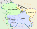 descriptive, non-topographic, SVG map
 -
 non-descriptive, topographic, SVG map


- Request
- Hello! I need an SVG map based off the info provided in the jpg CIA map above please. It is supposed to be a merger of maps 2 and 3 but with more detail. Thank you --𐩣𐩫𐩧𐩨 Abo Yemen (𓃵) 10:24, 7 May 2025 (UTC)
- This user is attempting to change a Wikiprojects India Pakistan China consensus of August 2019 for the topographic CIA map which was made by professional cartographers. They have impulsively come here. Fowler&fowler (talk) 10:29, 7 May 2025 (UTC)
- Yes it is. I have told you that I am going to start an RfC there, and Commons has nothing to do with this. I've already told you on that discussion that consensus can change. You already said that you aren't going to continue this discussion, but are now trying to do so on commons? 𐩣𐩫𐩧𐩨 Abo Yemen (𓃵) 14:41, 7 May 2025 (UTC)
- This user is attempting to change a Wikiprojects India Pakistan China consensus of August 2019 for the topographic CIA map which was made by professional cartographers. They have impulsively come here. Fowler&fowler (talk) 10:29, 7 May 2025 (UTC)
- Graphist opinion(s)
 Request taken by LápizRoto (talk) 11:32, 16 July 2025 (UTC)
Out-of-date sailing conferences map
[edit]-
 Current map, depicting six conferences

Article: en:Inter-Collegiate Sailing Association
- Request
- Since this map was created, the NWICSA has spun off and become its own conference. See the current conferences here. Thank you! Additionally, maybe this map could be converted to SVG? —BhamBoi (talk) 03:59, 15 July 2025 (UTC)
- Done BorysMapping (talk) 07:46, 16 July 2025 (UTC)
- Sorry to reopen this, but I just realized that the NWICSA conference was dissolved soon after its creation, and no longer exists. Would it be possible to have another version of the map that does include it for historical purposes while keeping a version without it? Sorry for the confusion with my original request and thank you in advance for any updates! BhamBoi (talk) 02:44, 17 July 2025 (UTC)
- I reverted the upload, not sure if there is a reason to make a copy? if you want you can copy my edit and upload it as a new file. BorysMapping (talk) 07:54, 30 July 2025 (UTC)
- Sorry to reopen this, but I just realized that the NWICSA conference was dissolved soon after its creation, and no longer exists. Would it be possible to have another version of the map that does include it for historical purposes while keeping a version without it? Sorry for the confusion with my original request and thank you in advance for any updates! BhamBoi (talk) 02:44, 17 July 2025 (UTC)
- Graphist opinion(s)
Cannabis maps
[edit]

Article(s): en:Legality of cannabis, en:Cannabis in the Czech Republic
- Request
Can someone please change the Czech Republic to orange on the first map (File:Map-of-world-cannabis-laws.svg) and green on the second (File:Legality of Cannabis in Europe.svg)? Cannabis is not currently legal in the Czech Republic but is decriminalised. It won't be legalised until 1 January 2026, then it can be changed to blue, but it shouldn't be blue on either map now. Helper201 (talk) 12:33, 19 August 2025 (UTC)
- You left this message on my talk page, and I explained that both maps display laws that haven't yet come into effect. The same was done with previous jurisdictions and is consistent with other cannabis-themed maps such as those of the United States. --Ratherous (talk) 22:44, 19 August 2025 (UTC)
- And as I explained, consistency does not make anything correct. The map is displaying wrong information. That is factually correct to say. It doesn't matter how many times you do something wrong; it will always be wrong. Neither this map nor any other should be displaying information that is not currently factually correct. How is a Wikipedia reader (i.e. a non-editor) supposed to know which laws are current and which are future looking at these maps? They can't. Therefore, I posted here because you seemed unwilling to make this change and we seemed to be at an impasse. Helper201 (talk) 16:42, 20 August 2025 (UTC)
- If you would like to change the policy the maps follow you would have to have a discussion regarding doing so for both of those maps, not unilaterally demand someone makes changes for you. Also the Wikipedia articles do indeed expand on dates the laws come into effect, so the readers do very much have access to this information. Not to mention, one of the maps is literally a map I created and uploaded. --Ratherous (talk) 17:03, 20 August 2025 (UTC)
- And where has such a "policy" been formed in the first place and where would it be changed? I have "demanded" nothing, I made a request. I don't see anywhere on these maps where it states that the legalisation for the Czech Republic hasn't actually happened yet. Finally, you might like to read en:WP:OWN.
- Also, Mexico is flat-out wrong. Cannabis is decriminalised in Mexico, not legalised. Helper201 (talk) 04:02, 26 August 2025 (UTC)
- There has been a consistent pattern not only with this map, but as I mentioned previously, with other cannabis-themed maps from other regions with numerous precedents from previous jurisdictions legalizing the substance. Again, this is not exclusive to cannabis-themed maps, but also certain other legal visualizations, an example of which I have previously provided for you. I hope you realize Wikipedia and Commons are different projects and en:WP:OWN differs from COM:OWN. I don't think me inviting you to engage in a discussion over this issue in any way exhibits over-possessiveness over my upload in a manner that is contrary to COM:OWN. All files on Commons have talk pages, similarly to WP articles, which would, of course, be the appropriate location for a discussion. Your comment regarding Mexico would likewise be appropriate on the map's talk page - considering you provide sources and clearly back-up your claim, someone is very likely to respond either in favour or in opposition relative to the provided arguments. As you said yourself, "Therefore, I posted here because you seemed unwilling to make this change and we seemed to be at an impasse." Once you received push-back regarding your request on one user's talk page, your immediate reaction was to repeat your request elsewhere rather than opt for a wider discussion on the map's talk page - I'm not sure how not to perceive that as a demand over all else. Being at an "impasse" over content-related issues would be an appropriate point to start a wider discussion on both WP and on Commons. --Ratherous (talk) 01:27, 28 August 2025 (UTC)
- If you would like to change the policy the maps follow you would have to have a discussion regarding doing so for both of those maps, not unilaterally demand someone makes changes for you. Also the Wikipedia articles do indeed expand on dates the laws come into effect, so the readers do very much have access to this information. Not to mention, one of the maps is literally a map I created and uploaded. --Ratherous (talk) 17:03, 20 August 2025 (UTC)
- And as I explained, consistency does not make anything correct. The map is displaying wrong information. That is factually correct to say. It doesn't matter how many times you do something wrong; it will always be wrong. Neither this map nor any other should be displaying information that is not currently factually correct. How is a Wikipedia reader (i.e. a non-editor) supposed to know which laws are current and which are future looking at these maps? They can't. Therefore, I posted here because you seemed unwilling to make this change and we seemed to be at an impasse. Helper201 (talk) 16:42, 20 August 2025 (UTC)
- Graphist opinion(s)
Age of majority
[edit]
Article(s): en:Age of majority
- Request
- Some of the colours used for the ages on this map are too similar to each other and could cause problems for people with colour-blindness and other sight related issues. Specifically, the ages for 15/16 and 21 are very similar (seem to both be shades of orange) and the ages of 19 and 20 are also very similar in that they are both shades of blue. I would propose more distinct colour differences and would recommend changing the age of 21 to black and 20 to red. Helper201 (talk) 23:27, 26 August 2025 (UTC)
![]() Request taken by cmglee – Agreed that the colours should be updated. Having brownish colours for both lowest and highest values may confuse readers. Additionally, as the map is mostly green, that colour's saturation can be decreased. However, the map is used on many articles and updating legends will need much work. cmɢʟee ⋅τaʟκ 15:21, 28 August 2025 (UTC)
Request taken by cmglee – Agreed that the colours should be updated. Having brownish colours for both lowest and highest values may confuse readers. Additionally, as the map is mostly green, that colour's saturation can be decreased. However, the map is used on many articles and updating legends will need much work. cmɢʟee ⋅τaʟκ 15:21, 28 August 2025 (UTC)

Recoloured and legend added - @Helper201: Is this better?
cmɢʟee ⋅τaʟκ 14:30, 29 August 2025 (UTC)

- @Cmglee: its definetly better. However, I think it needs at least one change. <16 is very vague (could be anything from 0 to 15) and there is only one country among these that sets an age lower than 16 that I could find and that's Indonesia. I'd recommend setting a new colour for 15 and marking this in the key to be clearer and then "<16" in the key can be simple changed to "16". Maybe use black for 15 and "LightSlateGray" for 16? Helper201 (talk) 17:43, 1 September 2025 (UTC)
- @Helper201: It is no vaguer than the original, which states "age 16 or younger". Nevertheless, if it is indeed true that only Indonesia is lower than 16, I'll make the change. Can someone please confirm?
- Thanks, cmɢʟee ⋅τaʟκ 19:24, 1 September 2025 (UTC)
- @Cmglee: my apologies, I didn't mean to say that you made it worse, just that it could be made better than it was in the first place (i.e. before it was changed) by being less vague. Regarding Indonesia being the only country under 16, see here. Helper201 (talk) 19:38, 1 September 2025 (UTC)
- @Helper201: No worries, and thanks for clarifying.
- Delving deeper into the question, 2001:1970:56df:7d00:d09e:3d3:80f8:7257 (talk · contribs) removed Yemen from the age-15 category in this edit. The previous reference is now invalid.
- http://worldpopulationreview.com/country-rankings/age-of-majority-by-country still states that it's 15 but cites Wikipedia. Would you be able to find an authoritative source for Yemen, please?
- Thanks, cmɢʟee ⋅τaʟκ 12:01, 2 September 2025 (UTC)
- P.S. The article cites a "Constitution ot the Yemeni Republic" which states "3 - Age of Majority: eighteen full calendar years." http://natlex.ilo.org/dyn/natlex2/natlex2/files/download/83560/YEM83560.pdf concurs, so I've moved Yemen to age 18.
- Re colours, I made age 15 black and age 16 dark blue so that the colours get darker away from 18. cmɢʟee ⋅τaʟκ 12:16, 2 September 2025 (UTC)
- @Cmglee: my apologies, I didn't mean to say that you made it worse, just that it could be made better than it was in the first place (i.e. before it was changed) by being less vague. Regarding Indonesia being the only country under 16, see here. Helper201 (talk) 19:38, 1 September 2025 (UTC)
- @Cmglee: its definetly better. However, I think it needs at least one change. <16 is very vague (could be anything from 0 to 15) and there is only one country among these that sets an age lower than 16 that I could find and that's Indonesia. I'd recommend setting a new colour for 15 and marking this in the key to be clearer and then "<16" in the key can be simple changed to "16". Maybe use black for 15 and "LightSlateGray" for 16? Helper201 (talk) 17:43, 1 September 2025 (UTC)
Typos
[edit]-
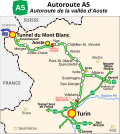 Italian A5 highway

Article(s): fr:Autoroute A5 (Italie)
- Request
- Hello,
Could you please correct a few typos on this map? There are some spelling mistakes in the names:
- Vallée [capital V]
- "Tunnel Suse de Fréjus" > "Suse [line break] Tunnel du Fréjus"
Thank you very much for your help! --Tenam2 (talk) 13:46, 27 August 2025 (UTC)
- Graphist opinion(s)
- Request taken by Ikonact (talk) 14:10, 27 August 2025 (UTC)
- @Tenam2, I corrected what you requested. Please let me know. --Ikonact (talk) 14:10, 27 August 2025 (UTC)
- @Ikonact Hi! Thank you for your quick reply. I would though need you to please correct one little detail, because it has to be "Suse [line break] Tunnel du Fréjus", and not "Tunnel [line break] Suse du Fréjus". Thank you in advance for your patience :) Tenam2 (talk) 12:57, 29 August 2025 (UTC)
- @Tenam2 done, and sorry for not doing it earlier. Ikonact (talk) 20:05, 29 August 2025 (UTC)
- No worries :) @Ikonact: Just a little last typo, as I wrote it should be "Tunnel du Fréjus", not "Tunnel de Fréjus". Thanks again :) Tenam (talk) 11:43, 1 September 2025 (UTC)
- @Tenam, @Tenam2: sorry, should be OK now.(I need to read better :-)) Ikonact (talk) 16:44, 1 September 2025 (UTC)
- No worries, thank you! Tenam (talk) 09:52, 2 September 2025 (UTC)
- @Tenam, @Tenam2: sorry, should be OK now.(I need to read better :-)) Ikonact (talk) 16:44, 1 September 2025 (UTC)
- No worries :) @Ikonact: Just a little last typo, as I wrote it should be "Tunnel du Fréjus", not "Tunnel de Fréjus". Thanks again :) Tenam (talk) 11:43, 1 September 2025 (UTC)
- @Tenam2 done, and sorry for not doing it earlier. Ikonact (talk) 20:05, 29 August 2025 (UTC)
- @Ikonact Hi! Thank you for your quick reply. I would though need you to please correct one little detail, because it has to be "Suse [line break] Tunnel du Fréjus", and not "Tunnel [line break] Suse du Fréjus". Thank you in advance for your patience :) Tenam2 (talk) 12:57, 29 August 2025 (UTC)
![]() Done--Ikonact (talk) 22:03, 4 October 2025 (UTC)
Done--Ikonact (talk) 22:03, 4 October 2025 (UTC)
Degoogling of funicular derailment map
[edit]-
 Done
Done

Article(s): 2025 Ascensor da Glória derailment (Q136090574)
- Request
- I request that this map published by the Portuguese public agency GPIAAF be traced over using OpenStreetMap (or another free alternative) and vectorised. it likely fails as copyvio, however, passing it through here before submitting it to deletion. --Juwan (talk) 23:35, 9 September 2025 (UTC)
- Graphist opinion(s)
- Request taken by cmglee: Failing to find any free aerial photographs showing the route, I'll use OSM. cmɢʟee ⋅τaʟκ 10:02, 10 September 2025 (UTC)
- Done @Juwan: File:Gloria_funicular_accident_map.svg is ready for translation into other languages. cmɢʟee ⋅τaʟκ 17:21, 10 September 2025 (UTC)
Correcting names
[edit]Article(s): File:Karte Sesvennagruppe.png
- Request
- This image uses the less common German names for Lower Engadine towns along with the Romansh ones. Specifically, "Fetan" is more commonly known as "Ftan" and "Schuls" more commonly as "Scuol". Can this be standardized to use the Romansh names i.e replace "Fetan" with "Ftan" and "Schuls" with "Scuol"? --Jo-Jo Eumerus (talk) 09:55, 22 September 2025 (UTC)
- Graphist opinion(s)
- Request taken by --please ping me-- Goran tek-en (talk) 17:09, 18 October 2025 (UTC)
- Uploaded new version, check it, thanks.
![]() Done --please ping me-- Goran tek-en (talk) 17:09, 18 October 2025 (UTC)
Done --please ping me-- Goran tek-en (talk) 17:09, 18 October 2025 (UTC)
@Jo-Jo Eumerus: The requester is supposed to put out this code so the request can be archived, I do it now.
- @Goran tek-en: Sorry, I hadn't noticed that this request had been fulfilled. Jo-Jo Eumerus (talk) 09:41, 23 November 2025 (UTC)
Silk Route Map
[edit]-
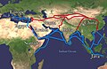 Silk Route

Article(s): en:Trade, en:History of India etc.
- Request
- [On the map] Differentiate between continent name (e.g., Europe) and country names (e.g., Somalia, India, Persia, Java, Arabia etc.). One label (Mediterranean Sea) is not straight. Please reduce the thickness of the blue and red lines, if possible. Thanks!
--JamesMdp (talk) 09:38, 30 September 2025 (UTC)
- Graphist opinion(s)
- @JamesMdp: I suggest this should be created as a svg, the only issue then would be the background map.
- Does it need to show different types of vegetation/topographic? --please ping me-- Goran tek-en (talk) 15:58, 18 October 2025 (UTC)
- If a new SVG image is created, it would be a big task to replace the existing JPG in every article. It's better to overwrite the image with a new, high-quality JPG instead. As for the background, please keep it the same. Thanks! JamesMdp (talk) 13:55, 24 October 2025 (UTC)
Falklands in the 1983 elections in Argentina
[edit]-
.svg/60px-Elecciones_presidenciales_de_Argentina_1983_(porcentaje_por_provincia).svg.png) Maps with the results of the 1983 presidential elections in Argentina
Maps with the results of the 1983 presidential elections in Argentina -
.svg/60px-Elecciones_presidenciales_de_Argentina_1983_(colegio_electoral).svg.png) Description of second image (if needed)
Description of second image (if needed) -
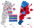 Description of third image (if needed; don't request too many at once, though)
.svg)
.svg)

Article(s): en:1983 Argentine general election
- Request
- The map includes the results of the elections at all the districts of Argentina, including the Falkland Islands (the pair at the bottom center). Those are only claimed by Argentina, but currently (and also by then) are a British territory, nobody actually voted in those elections there. They should be either painted in blank, or even removed. I don't know how to edit SVG files. --Cambalachero (talk) 03:50, 6 October 2025 (UTC)
- Graphist opinion(s)
File:Threshold of originality world map.svg content issue
[edit]-
 Problematic content: Crimea, Ukraine, Russia

- Request
- Please fix the colour shading of the en:Crimea part. Since the map's inception, it's in the shade given to Russia, but that's politically wrong. Virtually no state body outside of Russia's supporters recognise en:Crimea as legitimate part of Russia, despite its annexion claims. It must be in the shade given to en:Ukraine. Thanks! Regards, Grand-Duc (talk) 05:23, 9 October 2025 (UTC)
- Graphist opinion(s)
- @Grand-Duc: But this map has nothing to do with politics to my understanding.
![]() Done --please ping me-- Goran tek-en (talk) 13:34, 19 October 2025 (UTC)
Done --please ping me-- Goran tek-en (talk) 13:34, 19 October 2025 (UTC)
Typos
[edit]-
 Aiguille Blanche de Peuterey
 -
.png/120px-Grand_Eyvia_(2).png) Cogne Valley
Cogne Valley -
 Map of Aosta Valley's main castles and towns

.png)

Article(s):
- Request
- Hello!
Could someone please help correct a few typos on these maps?
- Aiguille Blanche de Peuterey.png
- Add "Pointe" beside "Punta" (x3)
- Add "Pointe Innomée" beside "Punta Innominata"
- Add "Pic Louis-Amédée" beside "Picco Luigi Amedeo"
- “Mont Blanc de Courmayeur” should be corrected (missing 'u').
- Grand Eyvia (2).png
- "Ghiacciaio del Trayo" → "Glacier du Trajo"
- "SR47" → "RR47"
- Val d'Aosta. Principals viles i castells.jpg - (typos in Catalan)
- Title: Val → Vall
- 4. Fenis → Fénis
- 6. Verres → Verrès
- 9. Castel → Castell
Thank you in advance for your help! --Tenam2 (talk) 17:12, 10 October 2025 (UTC)
- Graphist opinion(s)
- Request taken by --please ping me-- Goran tek-en (talk) 15:45, 18 October 2025 (UTC)
- @Tenam2
- I have uploaded new version, you should check them.
- In the last I also edited Châtillon, hope that was correct. Otherwise just ping me, thanks.
- Done --please ping me-- Goran tek-en (talk) 15:52, 18 October 2025 (UTC)
- Brilliant! Thank you so much! Tenam2 (talk) 10:17, 20 October 2025 (UTC)
@Tenam2 The requester is supposed to put out this code so the request can be archived, I do it now.
Upper Volta addition needed
[edit]-
 Map of boycotting countries

- Article(s)
en:1980 Summer Olympics boycott
- Request
- Upper Volta does not appear shaded blue on this map, although the country did not attend the 1980 Summer Olympics, according to the official list of competitor NOCs (Upper Volta, had it competed, would have shown on the list as VOL). -- Spintendo 21:34, 13 October 2025 (UTC) updated 06:06, 17 October 2025 (UTC)
- Graphist opinion(s)
Confusing map
[edit]-
 Distribution map of Budgerigar

Article(s): Category:Melopsittacus undulatus (distribution maps) and elsewhere
- Request
- The dark blue (indicating the temperate zone) is much too dark, making it look like the main objective of the map (i.e., where Budgerigars occur), rather than just another climate zone. Please make it a much paler shade, comparable to the other climate zones in colour intensity (I don't have svg-editing software so can't do this myself). I'd suggest #80eecc for the new colour. Once done, I'll undertake to edit the keys on all the wikipedia pages the map is used on to clarify the new colour. - MPF (talk) 16:17, 19 October 2025 (UTC)
- Graphist opinion(s)
- I updated the SVG image. You may have to flush some browser caches to see it. Thank you for suggesting a specific color, and one that doesn't look like it is trying to indicate water. – b_jonas 11:01, 24 October 2025 (UTC)
- That's superb, thanks! - MPF (talk) 21:05, 24 October 2025 (UTC)
Via Francigena map - French and Italian version
[edit]-
_4IT-1_Valle_de_Aosta.svg/120px-VF_(region)_4IT-1_Valle_de_Aosta.svg.png) Via Francigena - Aosta Valley section
Via Francigena - Aosta Valley section
_4IT-1_Valle_de_Aosta.svg)
Article(s):
- Request
- Hello!
Could someone please help create the French and Italian version of this map? These are the official and most important languages for this section of the Via Francigena.
- French version
- Valle de Aosta > Vallée d'Aoste
- Capital regional > Chef-lieu régional
- Capital provincial > delete
- Población > Ville / village
- Recorrido > Parcours
- Puerto del Gran San Bernardo > Col du Grand-Saint-Bernard
- Echevennoz > Échevennoz
- Italian version
- Valle de Aosta > Valle d'Aosta
- Capital regional > Capoluogo regionale
- Capital provincial > delete
- Población > Città / villaggio
- Recorrido > Percorso
- Puerto del Gran San Bernardo > Colle del Gran San Bernardo
- Echevennoz > Échevennoz
Thank you in advance for your help! --Tenam2 (talk) 17:12, 10 October 2025 (UTC)
- Graphist opinion(s)
Your source is not a true svg it has a bitmap within it. I will create true (only) svg for your translations.
![]() Request taken by --please ping me-- Goran tek-en (talk) 14:19, 22 November 2025 (UTC)
Request taken by --please ping me-- Goran tek-en (talk) 14:19, 22 November 2025 (UTC)
Diplomatic missions of Syria
[edit]-
 Diplomatic missions of Syria
 -
 Diplomatic missions in Syria


Article(s): en:List of diplomatic missions of Syria / en:List of diplomatic missions in Syria
- Request
- Could someone vectorize these maps? Many thanks in advance. --Yeagvr (talk) 00:39, 2 November 2025 (UTC)
- Graphist opinion(s)
SVG separatist world map
[edit]-
 World map with all successful movements
 -
SVG

Article(s): جداییخواهی
- Request
- I request an SVG version of this simple world map. --ANOTHERWlKlPEDlAN wɑit thɑt’s ɑ typo 23:08, 12 November 2025 (UTC)
- Graphist opinion(s)
Corrections in SVG map
[edit]- Request
Hi! With a group of users at eswiki and enwiki, we're developing a Lua module for creating colored maps (see w:Plantilla:Map, w:Module:Map and w:Module:Map/world for the data). The module is just starting but it's already finding its way into real articles. We originally imported the SVG data from https://simplemaps.com/resources/svg-world (license). However, we recently found some errors with the SVG data and would appreciate it if someone more acquainted with maps and SVGs could help us fix them!
- Galápagos Islands are missing
- Western Sahara is being invaded by Morocco!
Thanks! Sophivorus (talk) 11:33, 25 November 2025 (UTC)
- Graphist opinion(s)
Update Québec area maps to correct boundary
[edit]
- General map
File:Localisation_de_la_ville_de_Québec.svg
- Maps of boroughs
- File:Carte de l'arrondissement Beauport.svg
- File:Carte de l'arrondissement Charlesbourg.svg
- File:Carte de l'arrondissement La Cité-Limoilou.svg
- File:Carte de l'arrondissement La Haute-Saint-Charles.svg
- File:Carte de l'arrondissement Les Rivières.svg
- File:Carte de l'arrondissement Sainte-Foy–Sillery–Cap-Rouge.svg
- File:Carte des arrondissements et quartiers de Québec.svg
- File:Carte localisation Québec - La Cité–Limoilou.svg
- File:Carte localisation Québec - Beauport.svg
- File:Carte localisation Québec - Charlesbourg.svg
- File:Carte localisation Québec - La Haute-Saint-Charles.svg
- File:Carte localisation Québec - Les Rivières.svg
- File:Carte localisation Québec - Sainte-Foy–Sillery–Cap-Rouge.svg
- File:Quebec - Arrondissements.svg
- File:Quebec - Arrondissements2.png
- File:Quebec Arrondissements.svg
- File:QuebecCity location map with names.svg
- File:QuebecCity location map.png
- Maps of neighbourhoods
- File:Carte des arrondissements et quartiers de Québec.svg
- File:Localisation d'Orsainville dans Québec.svg
- File:Localisation de Bourg-Royal dans Québec.svg
- File:Localisation de Cap-Rouge dans Québec.svg
- File:Localisation de Chutes-Montmorency dans Québec.svg
- File:Localisation de Duberger-Les-Saules dans Québec.svg
- File:Localisation de l'Aéroport dans Québec.svg
- File:Localisation de la Cité-Universitaire dans Québec.svg
- File:Localisation de la Pointe-de-Sainte-Foy dans Québec.svg
- File:Localisation de Lac-Saint-Charles dans Québec.svg
- File:Localisation de Lairet dans Québec.svg
- File:Localisation de Loretteville dans Québec.svg
- File:Localisation de Maizerets dans Québec.svg
- File:Localisation de Montcalm dans Québec.svg
- File:Localisation de Neufchatel-Est-Lebourgneuf dans Québec.svg
- File:Localisation de Notre-Dame-des-Laurentides dans Québec.svg
- File:Localisation de Saint-Jean-Baptiste dans Québec.svg
- File:Localisation de Saint-Louis dans Québec.svg
- File:Localisation de Saint-Michel dans Québec.svg
- File:Localisation de Saint-Roch dans Québec.svg
- File:Localisation de Saint-Rodrigue dans Québec.svg
- File:Localisation de Saint-Sacrement dans Québec.svg
- File:Localisation de Saint-Émile dans Québec.svg
- File:Localisation de Sainte-Foy dans Québec.svg
- File:Localisation de Sillery dans Québec.svg
- File:Localisation de Val-Bélair dans Québec.svg
- File:Localisation de Vanier dans Québec.svg
- File:Localisation de Vieux-Moulin dans Québec.svg
- File:Localisation des Châtels dans Québec.svg
- File:Localisation des Jésuites dans Québec.svg
- File:Localisation des Laurentides dans Québec.svg
- File:Localisation du Plateau dans Québec.svg
- File:Localisation de Saint-Sauveur dans Québec.svg
- File:Localisation du Trait-Carré dans Québec.svg
- File:Localisation du Vieux-Bourg dans Québec.svg
- File:Localisation du Vieux-Limoilou dans Québec.svg
- File:Localisation du Vieux-Québec–Cap-Blanc–colline Parlementaire dans Québec.svg
- File:Quebec - quartiers - Aéroport.svg
- File:Quebec - quartiers - Cap-Rouge.svg
- File:Quebec - quartiers - Des Châtels.svg
- File:Quebec - quartiers - Duberger - Les Saules.svg
- File:Quebec - quartiers - Lac-Saint-Charles.svg
- File:Quebec - quartiers - Lairet.svg
- File:Quebec - quartiers - Loretteville.svg
- File:Quebec - quartiers - Maizerets.svg
- File:Quebec - quartiers - Neufchâtel est - Lebourgneuf.svg
- File:Quebec - quartiers - Saint-Émile.svg
- File:Quebec - quartiers - Val-Bélair2.svg
- File:Quebec - quartiers - Vanier.svg
- File:Quebec - quartiers - Vieux-Limoilou.svg
- Neighbouring municipalities
- File:Wendake Quebec location diagram.png
- File:L'Ancienne-Lorette Quebec location diagram.png
- File:Saint-Augustin-de-Desmaures Quebec location diagram.png
- File:Notre-Dame-des-Anges Quebec location diagram.png
- other municipalities
- File:L'Ange-Gardien (Capitale-Nationale) Quebec location diagram.png
- File:Beaupré Quebec location diagram.png
- File:Boischatel Quebec location diagram.png
- File:Château-Richer Quebec location diagram.png
- File:Lac-Jacques-Cartier Quebec location diagram.png
- File:Saint-Ferréol-les-Neiges Quebec location diagram.png
- File:Saint-Joachim Quebec location diagram.png
- File:Saint-Louis-de-Gonzague-du-Cap-Tourmente Quebec location diagram.png
- File:Saint-Tite-des-Caps Quebec location diagram.png
- File:Sainte-Anne-de-Beaupré Quebec location diagram.png
- File:Sault-au-Cochon Quebec location diagram.png
- File:Fossambault-sur-le-Lac Quebec location diagram.png
- File:Lac-Beauport Quebec location diagram.png
- File:Lac-Croche Quebec location diagram.png
- File:Lac-Delage Quebec location diagram.png
- File:Lac-Saint-Joseph Quebec location diagram.png
- File:Saint-Gabriel-de-Valcartier Quebec location diagram.png
- File:Sainte-Brigitte-de-Laval Quebec location diagram.png
- File:Sainte-Catherine-de-la-Jacques-Cartier Quebec location diagram.png
- File:Shannon Quebec location diagram.png
- File:Stoneham-et-Tewkesbury Quebec location diagram.png
_Quebec_location_diagram.png)
Article(s): en:Wendake, fr:Arrondissements et quartiers de Québec, en:La Cité-Limoilou, en:Les Rivières, Quebec City, en:Sainte-Foy–Sillery–Cap-Rouge, en:Charlesbourg, Quebec City, en:Beauport, Quebec City, en:La Haute-Saint-Charles, Quebec City, and many more.
- Request
- Can the aforementionned maps be updated to properly reflect the boundary of Wendake, the indigenous reserve/municipality?
- The boundary hasn't changed since the maps were made. The maps were never accurate since their inception.
- A good portion of the maps are based off of File:Localisation de la ville de Québec.svg
- I have contacted the original authors, and either have gotten no response or have been referred to here.
- The other parts of the map should stay the same
- I know that this a big request, please do let me know if it should be split. I thought it would be simpler to request them all in one shot.
- Thank you very much to the person that will pick this up! --Wolfy13399 (talk) 01:33, 26 November 2025 (UTC)
- Graphist opinion(s)